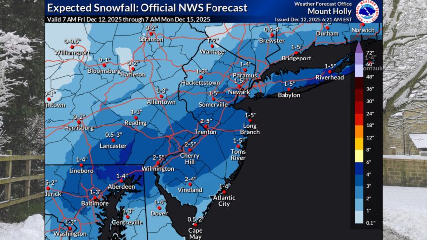
A winter storm poised to impact New Jersey this weekend is expected to deliver significant snowfall, with adjusted forecasts now predicting widespread totals of 1 to 4 inches across the state. According to the National Weather Service, snow is anticipated to commence Saturday night and persist into Sunday morning.
Initially, precipitation may begin as light rain or a rain/snow mix in regions south and east of Interstate 95. However, this is expected to transition swiftly to all snow, with the intensity of snowfall likely increasing early Sunday morning. The National Weather Service has particularly highlighted that the heaviest snowfall will be concentrated between midnight and sunrise on Sunday.
Areas along and south of Interstate 95, including coastal regions and southern counties, are forecast to receive between 2 to 4 inches of snow. In contrast, northern and northwestern sectors of New Jersey are expected to see totals ranging from 1 to 2 inches. While the overall snowfall forecast estimates 1 to 3 inches statewide, forecasters caution that conditions may alter should the storm system either accelerate or decelerate.
The storm is set to culminate with snow tapering off from west to east on Sunday morning through early afternoon, coinciding with the arrival of an Arctic front. Following the snowfall, forecasts indicate a notable drop in temperatures accompanied by increasing winds. Gusts reaching 25 to 30 mph will likely lead to areas of blowing snow and significantly impaired visibility.
As temperatures plummet Sunday night, wind chills may fall into the single digits, with certain northern regions experiencing temperatures approaching zero degrees. The cold snap will extend into Monday morning, when lows are expected to remain in the teens across much of New Jersey, particularly in far northern areas where they could dip near 10 degrees. The bone-chilling conditions will be exacerbated by sustained winds of 20 to 25 mph throughout Monday, making it feel even colder.
A slight reprieve from the harsh weather is anticipated by Tuesday, as conditions are projected to begin moderating, albeit still remaining cold with lighter winds. By Wednesday, temperatures should gradually rise, though they will remain below normal levels. The weather pattern is set to shift significantly on Thursday, bringing much milder air with temperatures expected to reach the 50s across most of New Jersey, accompanied by potential rain primarily in the afternoon and evening.


