Frigid temperatures and brisk winds are making for a challenging start to the day in the region. Weather forecasts indicate that while the actual cold is bearable, the wind significantly increases the chill factor, making it feel much colder outside. With wind gusts reaching upwards of 30 miles per hour, residents can expect feels-like temperatures around two degrees in Worcester and eight degrees in Boston. Plymouth’s wind chill comes in at nine degrees.
As the day progresses, these cold winds will persist, likely continuing into the afternoon before gradually subsiding in the evening. Despite the cold, there is some sunshine expected, offering a brief reprieve from the harsh conditions. However, temperatures will remain well below the seasonal average, only climbing to the low to mid-30s, whereas the typical highs during this time of year hover around the low 40s.
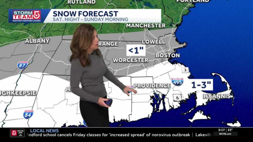
The next weather event on the horizon is a light snowfall anticipated Saturday night into Sunday morning. While the effects of this weather system will be minimal, areas south of Boston may see an accumulation of one to three inches of snow. The model suggests that those living along the South Coast, the Cape, and the islands are more likely to receive the higher totals, while areas further north may experience only a dusting or none at all.
Saturday is forecasted to be the more favorable day, with temperatures expected to rise into the upper 30s and low 40s. Clear skies during the day will transition to clouds in the evening as snow showers begin to move in, primarily affecting areas south of the Massachusetts Turnpike after midnight. By Sunday morning, light snow will be present but is expected to clear out by midday.
The cold snap will reassert itself on Monday, with predicted high temperatures only reaching the mid-20s, following a strong wind that will make it feel even colder. However, as the week continues, temperatures are projected to recover, with the possibility of approaching the 50-degree mark by next weekend. Residents are encouraged to stay updated with the latest forecasts as conditions can change rapidly.


